
“A frontier region… the resort of brigands and bandits”
– Sir Clifford Darby, from The Medieval Fenland
Two summers ago I walked coast to coast across England and Wales, from Great Yarmouth in Norfolk to Aberystwyth on the Welsh coast. The idea was to etch a furrow in the map along a route that traced familiar haunts and places of personal significance. My aim was to rekindle the memory of places I once knew in East Anglia and the Midlands; join up the dots, to connect all the places along the way with a line made by walking – a pagan pilgrimage, if you like, a personal songline.
I knew most of Norfolk well, or so I thought. The map of Norfolk was the back of my hand; its rivers etched by veins; the low hills of the Cromer Ridge, my knuckles. But the Fens, a territory that spanned the periphery of three counties, was another matter. This was a region I knew only from the window of a car or train.
As I understood it, the region was little more than a dried-out seabed given over to intensive farming; a place of no-frills functionality, of borrowed land and borrowed time. Before draining and being given over to arable farming the region was a swampy hinterland of marsh, rivers and low-slung islands. And before this, much of the Fen region had been a seabed, an extension of the North Sea, a region where the Situationist slogan, “Sous les pavés, la plage” might be corrupted to read “Sous les pavés, la mer”. Bandit country of a sort – impenetrable, unknowable to outsiders, this was where Hereward the Wake organised his raids on the hated Norman invaders, where, six centuries later, embittered natives lurked in wait to attack the Dutch engineers employed to drain and re-purpose its land use in the 17th century. Before the great drainage schemes were implemented the indigenous population was largely made up of eel catchers and wild-fowlers who lived pretty much outside the law. Some would say that this aspect of the Fens had still not vanished entirely – the whole region lay at the edge of polite society, the sort of place where taciturnity was worn like a badge of honour.
Today the region’s public image was little better: to many this low-lying no-man’s-land was a territory where outsiders were both unwelcome and ill-equipped to survive; a modern day realm of little Englanders, marginalised gypsies, east European farm workers, and gung-ho Ukippers.
All this was, of course, conjecture, perhaps mere stereotype: the image that some Fenlanders liked to project to the outside world. What of the reality? All I knew was that, motoring in either direction through long miles of relentless flatlands, it was always good to see hills once more, always a relief to be finally free of the tyranny of the horizon.
It took me several days to cross the Fens on foot. Here are three fragments of my account of that journey:
West of Wiggenhall, Norfolk
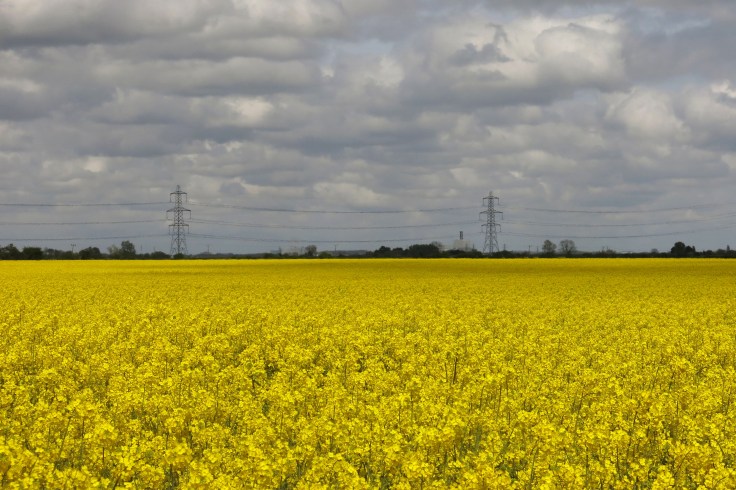
I left Wiggenhall St Germans to skirt the edge of an enormous field that took me a full half-hour to cross: a prairie of rapeseed oil, only a couple of trees growing in a ditch to break the monotony. A line of pylons stitched the sickly yellow foreground to the glowering sky. The effect was a binary illusion, a landscape that had been draped with a soiled Ukrainian flag. Crossing an arrow-straight drainage channel in which scummy green weed had clustered in rafts, I reached Islington. Little more than just a parish with a signpost, too small to describe as a hamlet, the village sign depicted a woman in country dress sat on a bank with herons flying about her. Next to this stood an expensive-looking concrete bench neatly inscribed Dr PUNSFER GIFT, a dog waste bin and a notice board that had parliamentary election notices locked behind glass. A self-conscious focal point in a vast land-sea of yellow and green, it seemed as if this little concentration of information and utility marked the coordinates of some sort of uncharted East Anglia pole of inaccessibility. It also made me wonder how many resting backsides would ever polish Dr Punsfer’s civic-minded bench.
This same Islington, I later discovered, was once a late Anglo-Saxon settlement of sufficient size to warrant inclusion in the Domesday Book, a modest village of salt houses complete with its own church. It was now a much depleted place.
Approaching Terrington St John, a hand-painted notice on a footpath shouted, THIS IS NOT A PUBLIC FOOTPATH with Ceci n‘est pas une pipe Magritte-style logic – the work of a local surrealist or, more likely, a curmudgeonly farmer, its forbidding message contradicted by the two yellow public footpath arrows that adorned the broken post to which it was affixed. I followed it anyway.

West of Wisbech, Cambridgeshire I had heard the town referred to as Wisbechistan by some Fen-dwellers. Like the doubled offensiveness of calling an Iranian an Arab, what better way of showing contempt than blurring the ethnicity and dismissing the culture of those who were despised? The Persian suffix ‘stan’ came, of course, with its own (suicide backpack) baggage thanks to a misplaced notion of it being a signifier of terrorism rather than simply ‘homeland’ or ‘country of’, which it translated as.
Beyond Wisbech the landscape gave way to an un-beautified realm of plain functionality: no rural quaintness, modest low houses, nothing older than Victorian, tucked behind tall dark windbreaks of Leylandii. Large prefabricated hangars slumped over the black-soil fields like tents at a crime scene. The loose, sun-bleached fabric of abandoned plastic greenhouses flapped in the breeze. NO ENTRY signs started to become more numerous, as did warnings that proclaimed. FARM ALARMED and DOGS RUN LOOSE. Every house seemed to have a barking dog that aggressively challenged anyone who had the effrontery to pass their territory on foot. Even an atypically pretty cottage, where you might imagine a sweet old couple living, had signs warning, unapologetically, DOGS RUNNING FREE.
The landscape opened up a little, still table-flat but gradually rising. Following a bridleway, I came across a defunct washing machine abandoned in a ditch, a white goods totem offering in an expanse of field and sky, its load door peeping open above the water like the hatch of a surfacing submarine. I startled a skulking heron and the bird rose from the ditch just a few feet away from me, close enough to look into its fierce orange eye before it flapped away. Above, in a remote cerulean sky, a kestrel hovered like an aerial signpost.
Back on a minor road I passed more new-build houses. One house had been constructed as a simulacrum of a converted old farm building (that had never actually stood here): faux history; not so much reinventing the past as making it up. Beyond the new houses were paddocks with signs that just simply bore the postcode, PE (Peterborough). No village, no hamlet, no real address, this was nowhere… although it did have a postcode.
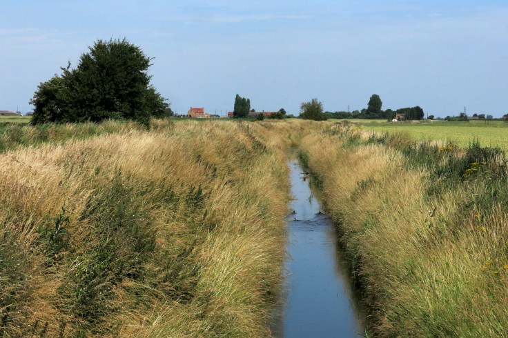
Approaching Throckenholt, Lincolnshire The arrow-straight North Level Main Drain limned the border with Lincolnshire. The road sign marking Harold’s Bank had almost been redacted by yellow-green lichen, which had taken hold on the black letters to render it almost illegible. FISHING IS PRIVATE notices along the bank offered a detailed Polish and Lithuanian translation. For additional clarity there was also a crossed-through picture showing a fish on a cooking griddle, and another that depicted a man running with a large fish tucked under his arm — graphic signifiers of native Fenlander versus east European cultural differences. As I was examining these anti-fishing proscriptions, a couple of red-headed teenage boys passed by on bicycles. Both carried fishing rods, clearly with intent. The pair stopped a little further along the bank to examine the water for fish but thought better of it and remounted their bikes in search of a more secluded spot.
At the twin-arched bridge at Clough’s Cross I crossed into Lincolnshire and walked a mile or so along the road to Throckenholt. The bus stop stood at the corner of a lane of council houses that stretched back to the Cambridgeshire border. A hand-painted board on the verge advertised RASPBERRIES, HOME GROAN POTATOES! I was troubled with uncertainty as to whether the service existed at all but the bus, an empty double-decker, arrived on cue. I was the solitary passenger until we picked up a mother and baby at another village on the way to Spalding.
Laurence Mitchell is a writer and photographer with an interest in deep topography, frontier zones and territories in transition. He is author of several travel guides for Bradt and has written widely on walking and slow travel.

April 22, 2018 at 1:05 am
Is that kestrel hanging up there still? Eagles do that where I live, then corkscrew down to snatch gull chicks bobbing like miniature wood decoys in the spring lake.
LikeLike
April 23, 2018 at 5:55 pm
Reblogged this on East of Elveden and commented:
For this post I am reblogging something I recently wrote for The Arsonist, the webzine of Burning House Press.
LikeLike
April 24, 2018 at 4:10 pm
“Ceci n‘est pas une pipe Magritte-style logic – the work of a local surrealist …” Brilliant! I really enjoy your writing.
LikeLike
April 26, 2018 at 2:19 pm
Many thanks, Ian and Klausbernd. Glad that you both enjoyed it.
LikeLike
April 26, 2018 at 10:41 am
YES! I agree with Ian: Brilliant!
The whole text is brilliantly written and reminds me of the stories our gardener, a former Fenland boy, told me.
Thanks a lot for sharing
Klausbernd and the rest of The Fab Four of Cley
💃🚶♂️👭
LikeLike